 Skip to content
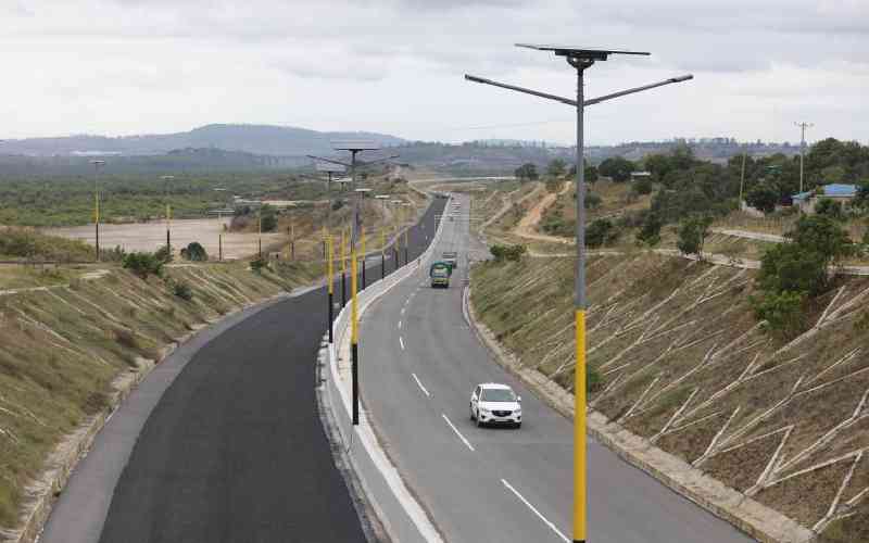
For decades, the mention of “Mombasa” was synonymous with the “Likoni Ferry bottleneck”—a two-hour wait that tested the patience of even the most relaxed traveler. But today, the narrative has shifted. Dongo Kundu is no longer just a project on a dusty blueprint; it is a sprawling, multi-billion-shilling reality that has redefined the geography of Kenya’s coast.
Whether you are a logistics manager looking at the Dongo Kundu weighbridge, a tourist searching for the fastest Dongo Kundu bypass to the Diani route, or an investor eyeing the Special Economic Zone (SEZ), this guide is your definitive resource.
Technical Breakdown: The Dongo Kundu Bypass Road & Bridges
The Dongo Kundu bypass—officially known as the Mombasa Southern Bypass Highway—is an 18-kilometer engineering feat designed to connect Mombasa Mainland West to Mombasa Mainland South without ever setting foot on Mombasa Island.
The Phase System
The project was executed in three distinct packages to ensure technical precision across varied terrains:
- Phase 1 (Completed 2018): A 10.1 km dual carriageway linking Miritini to Kipevu. This section was the first to ease the exit of heavy trucks from the Port of Mombasa, immediately reducing delays in the Changamwe area.
- Phase 2 (Completed 2024): The most complex section, an 8.9 km stretch connecting Mwache Junction through the Tsunza Peninsula to Mteza. This phase introduced the massive bridges that now define the region’s skyline.
- Phase 3 (Completed 2024): A 6.9 km road linking Mteza to Kibundani, which finally connects the entire bypass to the Likoni-Lunga Lunga Road.
Engineering Marvels: The Three Bridges
The highlight of the Dongo Kundu bypass design is its collection of bridges spanning both swamps and open ocean.
- Mteza Bridge: Straddling 1,440 meters (1.44 km), this is officially the longest bridge over water in Kenya and the entire East African region. It is roughly seven times longer than the Nyali Bridge.
- Mwache Bridge: Spanning 660 meters, this bridge carries the highway across the Mwache Creek immediately south of the Mwache Junction.
- Tsunza Viaduct: At 690 meters, this viaduct supports the road as it moves across the scenic Tsunza Peninsula.
The Dongo Kundu bypass contractor for Phases 1 and 3 was the China Civil Engineering Construction Corporation (CCECC), while Phase 2 was handled by the Fujita Corporation-Mitsubishi Corporation Consortium.
Operational Updates: Is the Dongo Kundu Bypass Open?
The question on every traveler’s mind: “Is the Dongo Kundu bypass open today?”
The answer is yes. In August 2024, the bypass was officially opened to the public. While the road is fully operational for motorists and pedestrians, it was opened at 96% completion to allow for immediate traffic relief.
Current Status as of January 2026:
- Access: The road is open 24/7 for cars, though heavy trucks were initially restricted to allow for final surface dressing and refinements.
- Refinements: Final touches, including road marking, installation of guard rails, and street lighting on the Mwache-Tsunza-Mteza section, were finalized following the partial opening.
- Toll Status: As of now, the road remains toll-free. It was built primarily through a Japanese loan (JICA) and support from the Kenyan government, though there are future plans to potentially convert it into a toll road under new national legislation.
Essential Travel Guide: Directions, Maps, and Distance
Using the Dongo Kundu bypass road isn’t just about saving time; it’s about a completely different scenery of the Kenyan coast.
Where does the Dongo Kundu bypass start?
The bypass begins at the Miritini Interchange, along the Nairobi–Mombasa Highway (A109). It is roughly 11 to 15 kilometers northwest of Mombasa’s CBD.
Step-by-Step Directions from Mombasa & SGR
From Miritini SGR/Highway: Look for the Miritini cloverleaf interchange. This is the gateway to the bypass.
Passing the Airport: The road curves around the western edge of Moi International Airport. You can even access the bypass via a 1.3 km link road specifically connecting the airport to the highway.
The Bridges: You will cross the Mwache Bridge, move through the Tsunza Peninsula, and then cross the record-breaking Mteza Bridge.
The South Coast Connection: The bypass ends at Ng’ombeni (Kibundani), where it merges with Likoni-Lunga Lunga Road.
The Diani Shortcut: Game-Changing Distance
For tourists, this is the “Damascus moment.”
- Old Route: Traveling from the Miritini SGR station to Diani via the ferry could take over 2.5 hours on a bad day.
- Bypass Route: The same journey now takes approximately 45 minutes.
Logistics & Commercial Impact: SEZ and the Weighbridge
Beyond personal travel, Dongo Kundu is the heart of Kenya’s industrial future.
The Dongo Kundu Special Economic Zone (SEZ)
The bypass serves as the critical artery for the Dongo Kundu Special Economic Zone, a 6,200-acre development designed to mirror the success of trade hubs like Dubai.
- Free Trade Zone: The SEZ includes a Dongo Kundu free port and an integrated industrial park.
- Operationalization: While the Dongo Kundu SEZ operationalization challenges (such as land use coordination) are being addressed, the infrastructure is already in place to support massive logistics units.
For Freight & Trucks: The Weighbridge
A dedicated Dongo Kundu weighbridge has been built along the Kipevu link road to monitor and manage heavy cargo moving between the port and the interior. This ensures the long-term durability of the Sh40 billion road.
Safety, Sightseeing, and Local Flavor
While it’s a highway, there’s a human side to this road.
- Speed Limit: The design speed for the Mombasa Southern Bypass Route-B is set at 80 km/h. In certain segments, like slip roads or grade-separated junctions, it drops to 50 km/h.
- The “Dongo Kundu View Point”: Motorists often stop (safely at designated bays) to take photos of the Mteza Bridge and the surrounding mangrove forests.
- Local Infrastructure: The project has also focused on the community, including improvements to roads serving the Dongo Kundu primary school and local community centers.
- The Dongo Kundu Meaning: In local Swahili, the name hints at the “red soil” or earth typical of the area.
FAQ
Is the Dongo Kundu Bypass open to the public today?
Yes, the Dongo Kundu Bypass is fully open. It was opened to the public in August 2024 and remains a key transit route for vehicles traveling between Mombasa Mainland West (Miritini) and the South Coast.
Where does the Dongo Kundu Bypass start and end?
The bypass starts at the Miritini Interchange on the Nairobi–Mombasa Highway (A109). It ends at the Kibundani/Ng’ombeni Interchange on the Likoni–Lunga Lunga Road. The total length of the dual carriageway is approximately 17.5 kilometers.
Are there toll charges to use the Dongo Kundu Bypass in 2026?
While currently free, a tolling plan is being finalized. As of late 2025, the government approved feasibility studies to introduce tolling under a Public-Private Partnership (PPP) model to repay the project's construction loans. Once implemented, it will be Kenya's second toll road after the Nairobi Expressway.
How much time does the bypass save compared to the Likoni Ferry?
The bypass is a significant time-saver. Travelers can now move from Miritini to Diani in roughly 45 minutes, whereas the old route through the Likoni Ferry often took over 2.5 hours due to congestion and ferry delays.
What is the longest bridge on the Dongo Kundu Bypass?
The Mteza Bridge is the most significant structure on the bypass. At 1.44 kilometers long, it is the longest bridge over water in East Africa, spanning the Port Reitz Bay to connect the mainland to the Dongo Kundu area.
Can I visit the Dongo Kundu Special Economic Zone (SEZ)?
The Dongo Kundu SEZ is primarily an industrial and logistics hub managed by the Kenya Ports Authority (KPA). While not a traditional "tourist attraction," visitors can see the progress of massive projects like the Taifa Gas LPG facility and the emerging free port areas from the bypass road.
The Dongo Kundu bypass is more than just asphalt and concrete. It is a relief to 700,000 residents and a boom for the 3,000 jobs it helped create. By slashing travel times and opening up the South Coast for investment, it has firmly established Mombasa as a world-class industrial hub and a premium holiday destination.
Whether you’re driving to the airport or hauling cargo to Tanzania, the Dongo Kundu bypass road is your new fast lane to success.